Today we dare to publish an untypically long blog-text of the expedition leader Rolf Stange. Rolf did guide our beloved Master and us around Svalbard and NE Greenland. He, a specialist for Spitsbergen and Bear Island, kindly wrote this text about an Arctic island at the end of the world. We will publish the whole English text first and then the German text because it’s easier to read. But you will find different pictures in both texts.
We Bookfayries wish you a happy journey to the end of the world, where Roald Amundsen died when he tried to rescue Nobile. For our bookworms we recommend the Bear-Island-novel by Martin Mosebach “Prince of the Mist”.
Heute trauen wir uns einen bloguntypisch langen Text des Expeditionsleiters Rolf Stange zu bringen. Rolf hat vor Jahren Masterchen mit uns durch Spitzbergen und NO Grönland geführt, was atemberaubend war. Als Spezialist für Spitzbergen und die Bäreninsel hat er lieberweise den folgenden Text über eine Insel der Arktis für unseren Blog geschrieben, die, wenn wir’s mal leger sagen dürfen, am Arsch der Welt liegt. Da der Text länger ist, werden wir erst den gesamten englischen, danach den gesamten deutschen Text bringen. So wird der Lesefluss nicht gestört. Beide Texte weisen unterschiedliche Bilder auf.
Wir wünschen viel Freude bei Reise ans Ende der Welt, dorthin, wo Amundsen bei seiner versuchten Rettung von Nobile, umkam. Für Leseratten empfehle ich, die liebkluge Buchfee Siri, Martin Mosebachs Bäreninsel-Roman “Der Nebelfürst”.
***
Bear Island: Boundary stone in a boundless sea
It is such a thing with these small islands in the middle of big seas. The more difficult it is to get there, the stronger the desire to get there nevertheless, one day. And the more effort nature seems to have put into creating something spectacular.
If you, thoughts like that in your mind, grab a chart of the north Atlantic, then you will quickly stumble over Jan Mayen and Bear Island. Both are icons for fans of remote islands. Far away from the next long coastline – and this is already pretty remote. Between them, hundreds of miles of open sea. Which may translate as many hours of seasickness. No, we don’t think about that now, that is not nice.
Jan Mayen would be a fascinating idea for a chapter in this blog, but that is not on the menue for today. Our virtual trip is going to Bear Island. We will do it the same way as many others over the centuries. Maybe already the Vikings did it like that – well, unlikely, but we don’t know for sure. In any case, explorers, scientists and whalers did it like that for centuries, leaving from Tromsø on a sailing boat, hoping the winds would be friendly.
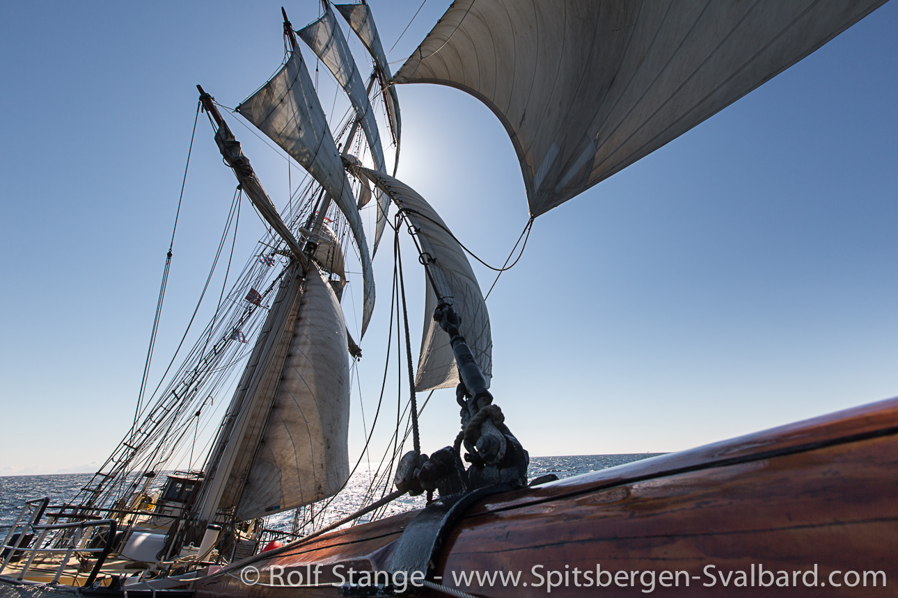
Well, we don’t do it exactly the same way. We also step on a sailing ship in Tromsø, but we are modern people. We don’t just hope for friendly winds. We just use the engine in case it is needed.
After some hours sailing through straits and fjords north of the old capital of the Barents Sea, the coastline of Norway slowly starts to disappear behind the horizon. The wind is filling the sails. 250 nautical miles sailing, or about 30 hours, if it works well.
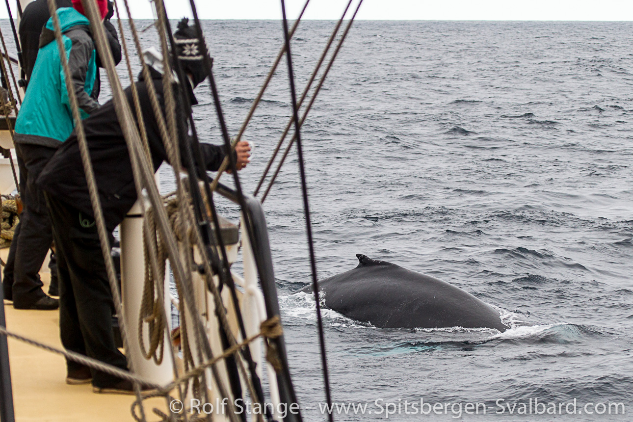
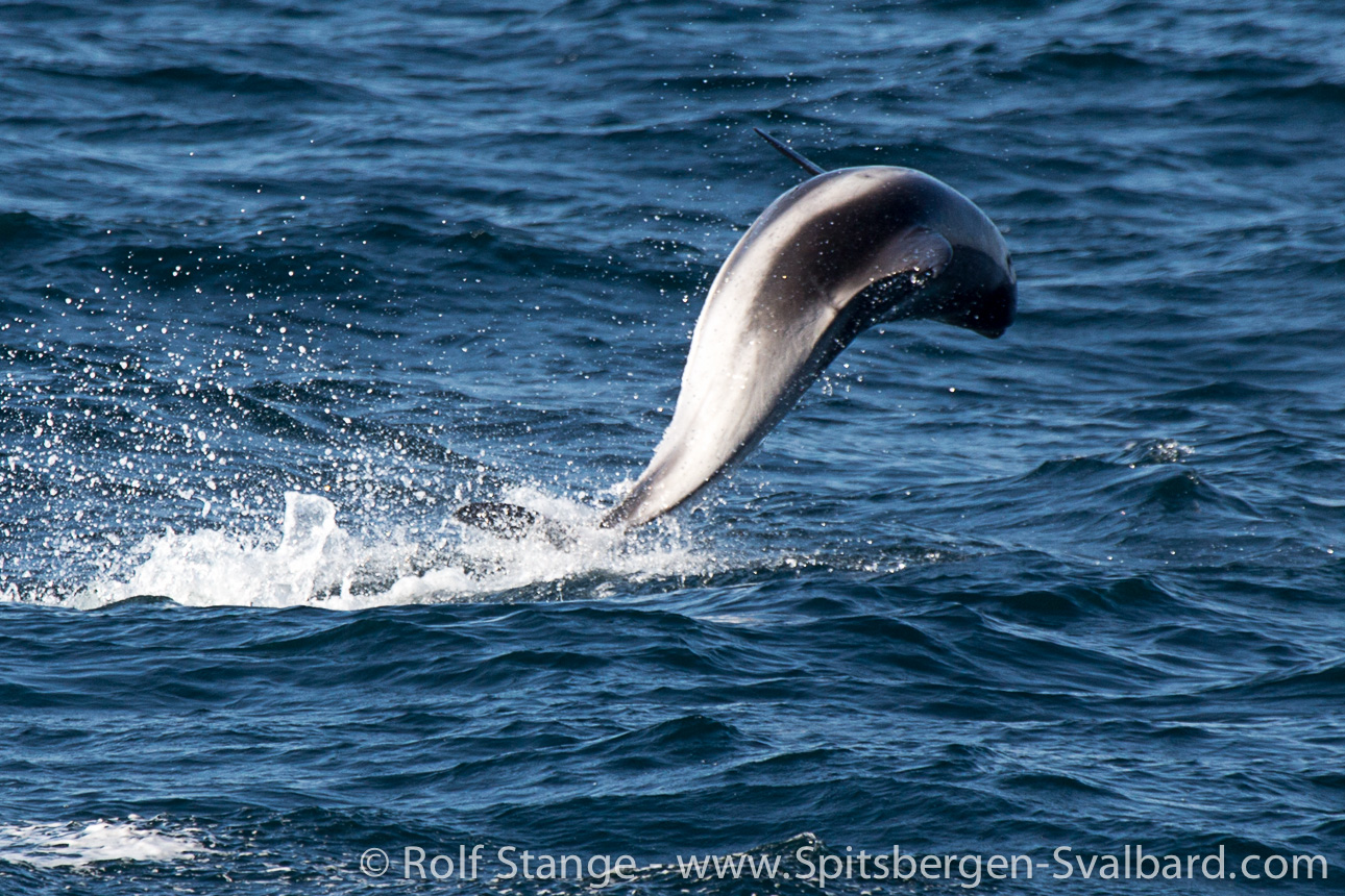
It does work well. In the company of humpback whales and white-beaked dolphins, kittiwakes and pomarine skuas, time is passing more quickly than we had thought. It is tough to leave the beauty of the Barents Sea on a fine early summer day to divert some thoughts to Bear Island, our rare destination.
William Barentsz was the first one we know for sure who was sailing on this route. He came from the Netherlands and not from Tromsø, but that does not matter. But it does make a difference that neither did he know that Bear Island was on his path, nor did he have any interest in going there. His destination was not a cold island in the high north, but the rich countries in the far east. He simply took a decidedly wrong turn in his attempt to find a new way to the Asian spice countries. On June 8, 1596, Barentsz sighted a new island coming out of the mist. During an attempt to get there with rowing boats, his crew was attacked by a big white bear. It took hours to send the bear to his ancestors. Since then, Bear Island has got its name, translated to Norwegian as Bjørnøya.
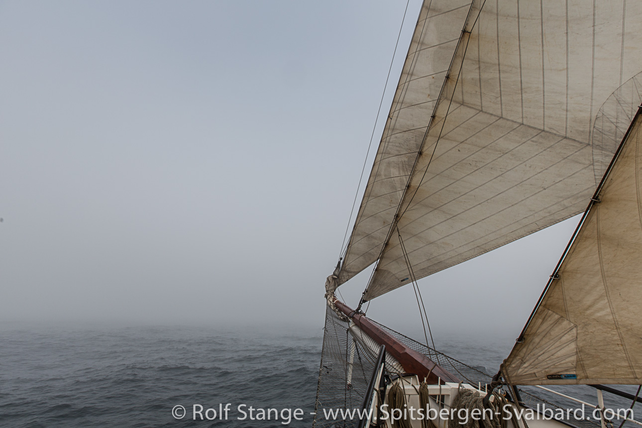
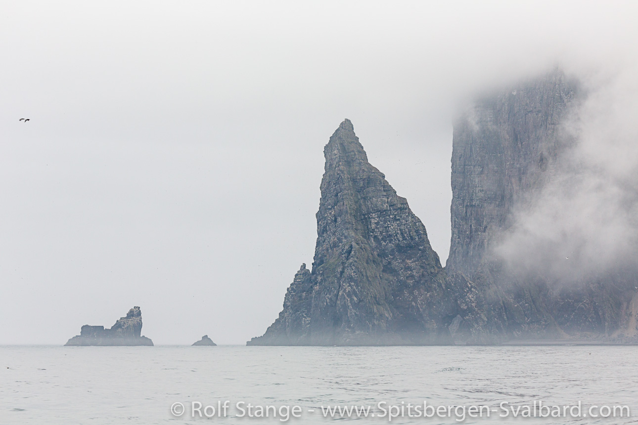
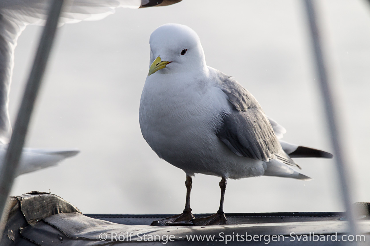
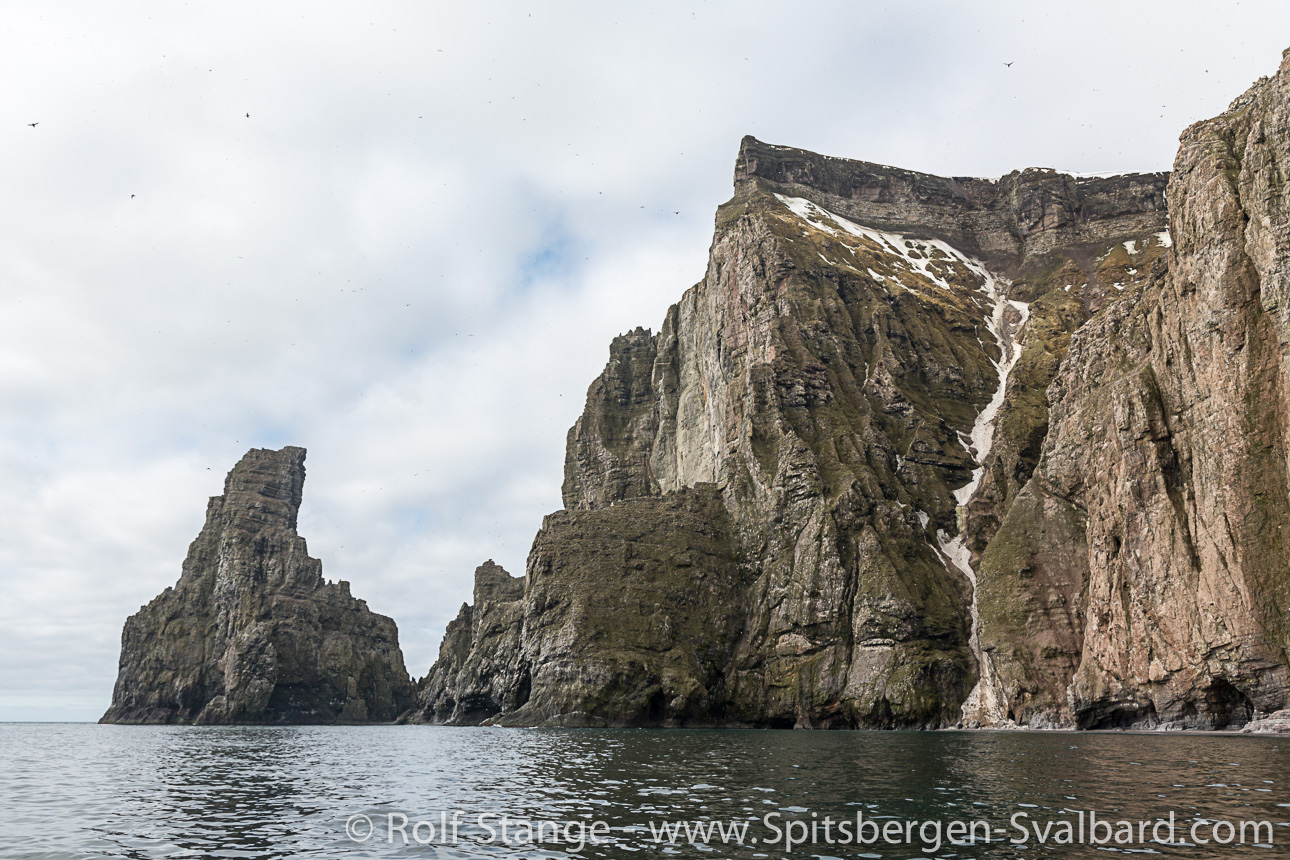
We also approach the island in fog. The area has a bad reputation for being foggy. If they have got something here, then it is fog. More and more noisy guillemots are coming out of the grey mist, land can’t be far anymore. And indeed, soon high, dark cliffs are towering above the grey fog banks.
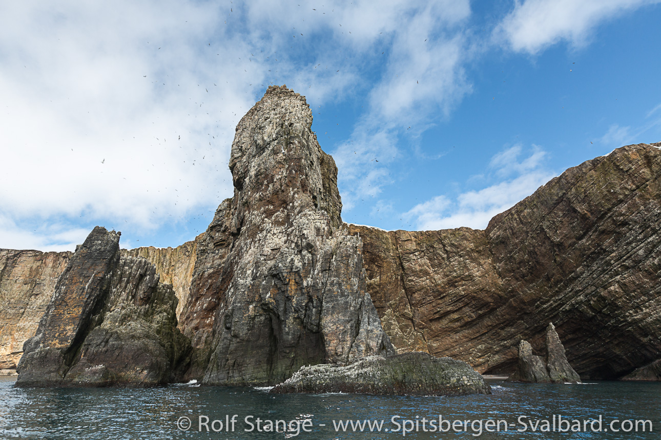
The southern tip of Bear Island is one of the great places nature has made in the north Atlantic. Vertical rockwalls 400 metres above the waves. Rock pinnacles show that the island has been larger in the geologically recent past. The highest of these towers is a mighty 191 metres high. The Lange Anna, a famous rock stack near Helgoland, is model railroad stuff, in comparison.
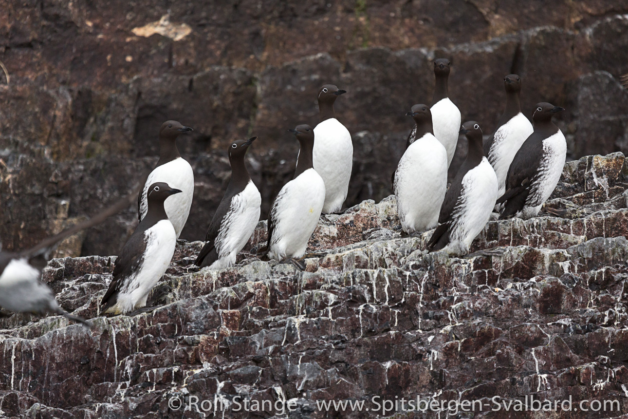
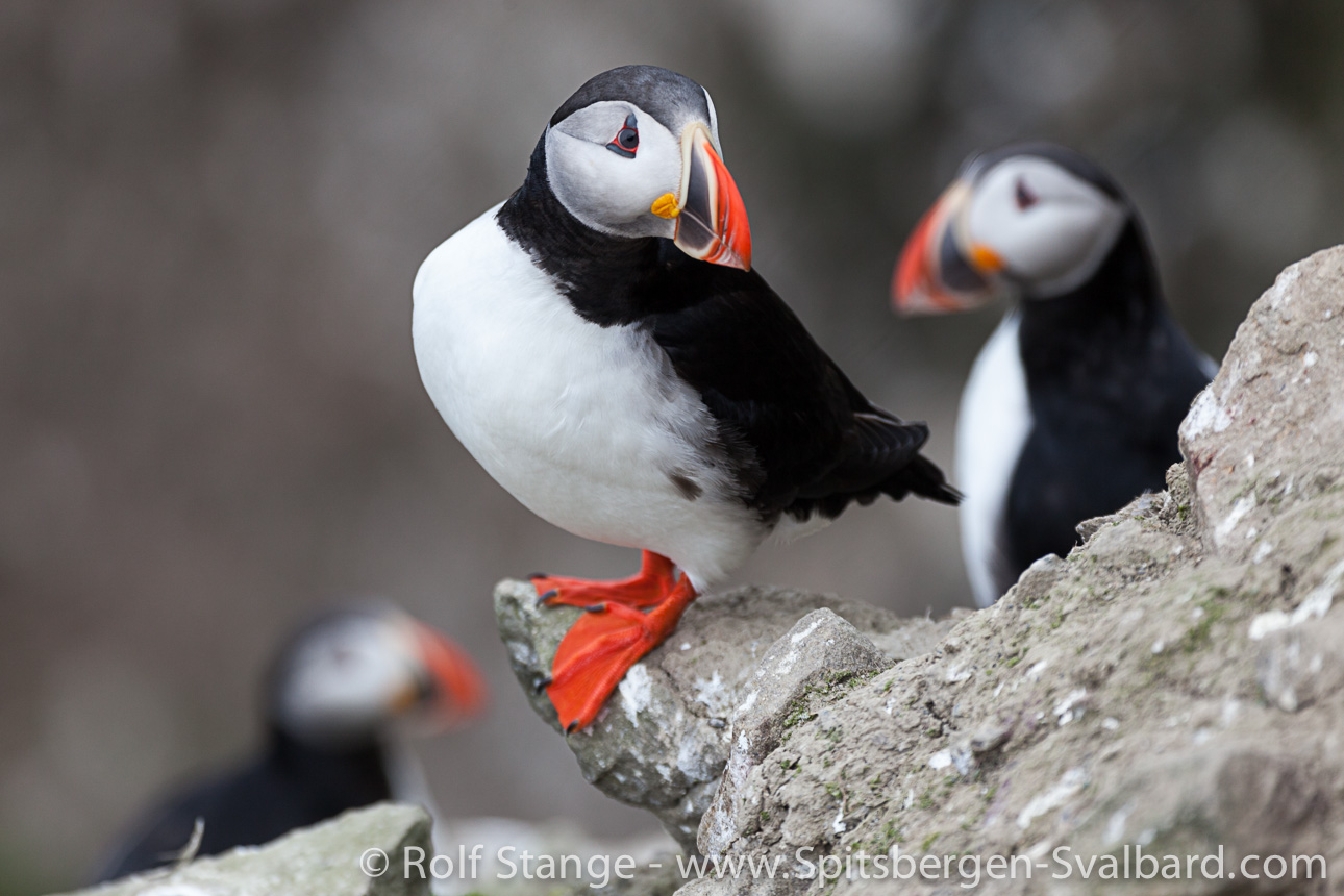
We have picked the best day to come. Usually, the winds are blowing strong and the waves are furious around the southern tip, but today it is calm enough so we can go around the spectacular cliffs in small boats. They say that the bird cliffs are amongst the largest in the northern hemisphere. You will believe it if you ever see them. Breeding pairs are counted in hundred thousands. It takes a close look to tell Common guillemots and Brünich’s guillemots apart. Both species are cousins, but they look almost like twins.
The Common guillemot is living in the sub arctic, that is in Norway, Scotland and Iceland. They are well known to North Sea birdwatchers. But just as the cliffs of Helgoland, the North Sea colonies are tiny compared to the madhouse of Bear Island. The Brünich’s guillemot, in contrast, is a high arctic species, known from Greenland and Spitsbergen. Here, both of them are sharing the same breeding cliffs. The shifting of invisible climate boundaries may enable one species in the future to push the other one off the ledges. The two species used to balance each other out in the past, largely. But in 1987, the local population of the Common guillemot collapsed so strongly that it has still not fully recovered. The capelin is their preferred diet, and back then, herrings and humans snatched it from their plate.
Another silent testimony of human carelessness is the rusty wreck of a Russian ship. The captain was drunk and the helmsman asleep when the Petrozavodsk ran straight into the cliffs in May 2009. The crew saved and so was nature thanks to a great effort of the Norwegian coastguards and related forces, as they managed to pump off diesel and carry things you really don’t want in the water from the ship before it was smashed by the waves. The best nature protection area does not help if people just break the rules. Bear Island has been declared a nature reserve in 2002.
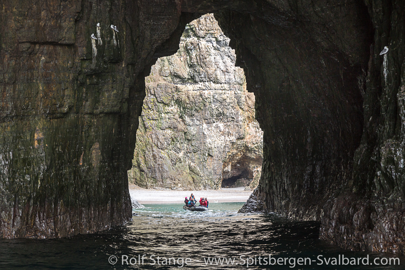
That is also the reason why we can’t use the ship to sail near the birdcliffs, we have to be content with the much smaller Zodiacs. But on the other hand, the ship would not fit through the pearl gate (Perleporten). That is a coastal cave, more than 100 metres long, smashed by the never-tired waves into Cape Kolthoff. Bear Island from inside is rather dark and wet. But who can honestly say to have seen Bear Island from inside?
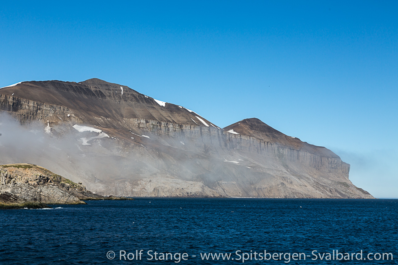
The island isn’t exactly big. Less than 10 miles to the northeastern part. We are sailing around Miseryfjellet, the island’s highest mountain. Its three peaks are named after the three Norse goddesses of destiny. But we can’t see them, the mountain tops are hidden in clouds. Who knows if they are at home. But they made life miserable for the explorers, the name of the mountain makes that quite unmistakable.
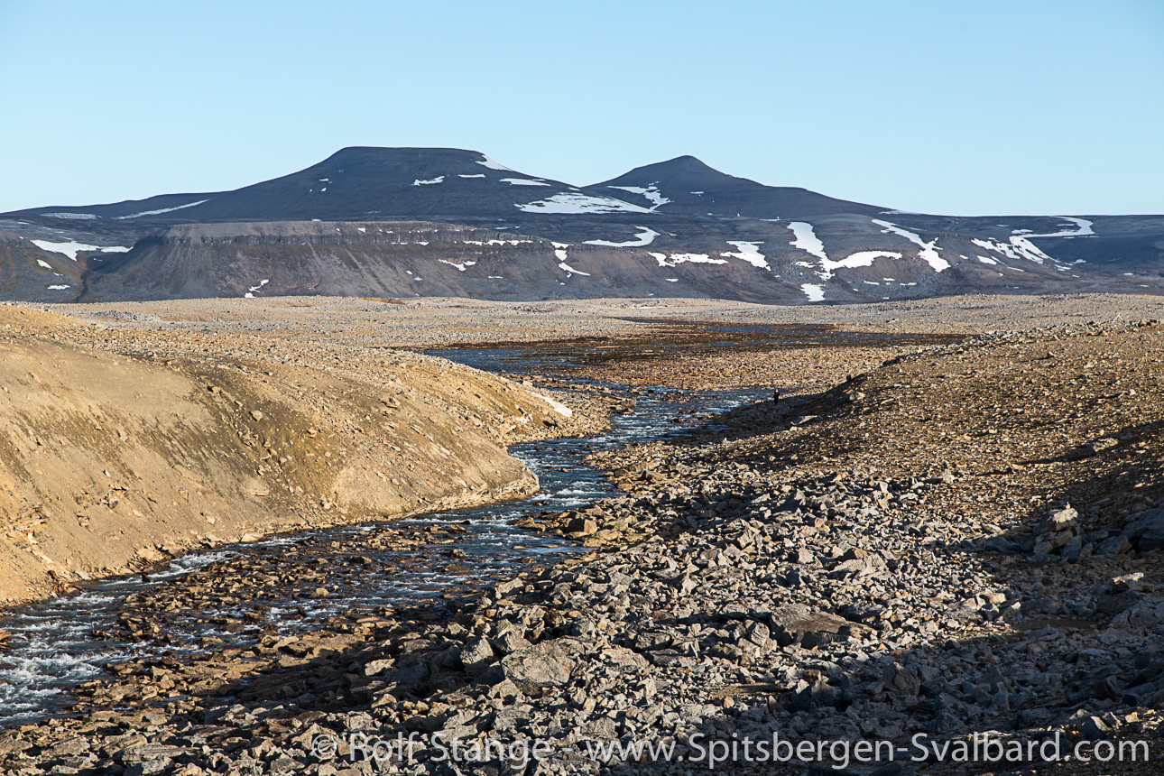
Bear Island shows a completely different face in its northern part. Is this really still the same island? Probably. Still a cliff coast, almost everywhere, but only 10-15 metres high. Very barren, rocky land behind the cliffs. Barren, more barren, Bear Island. And rocky. When God was done with the creation of the world, he just dumped all stones here he had not used up elsewhere. Well, it must have been the 8th day, a Monday, and the island was obviously never meant to be a place for humans to walk around.
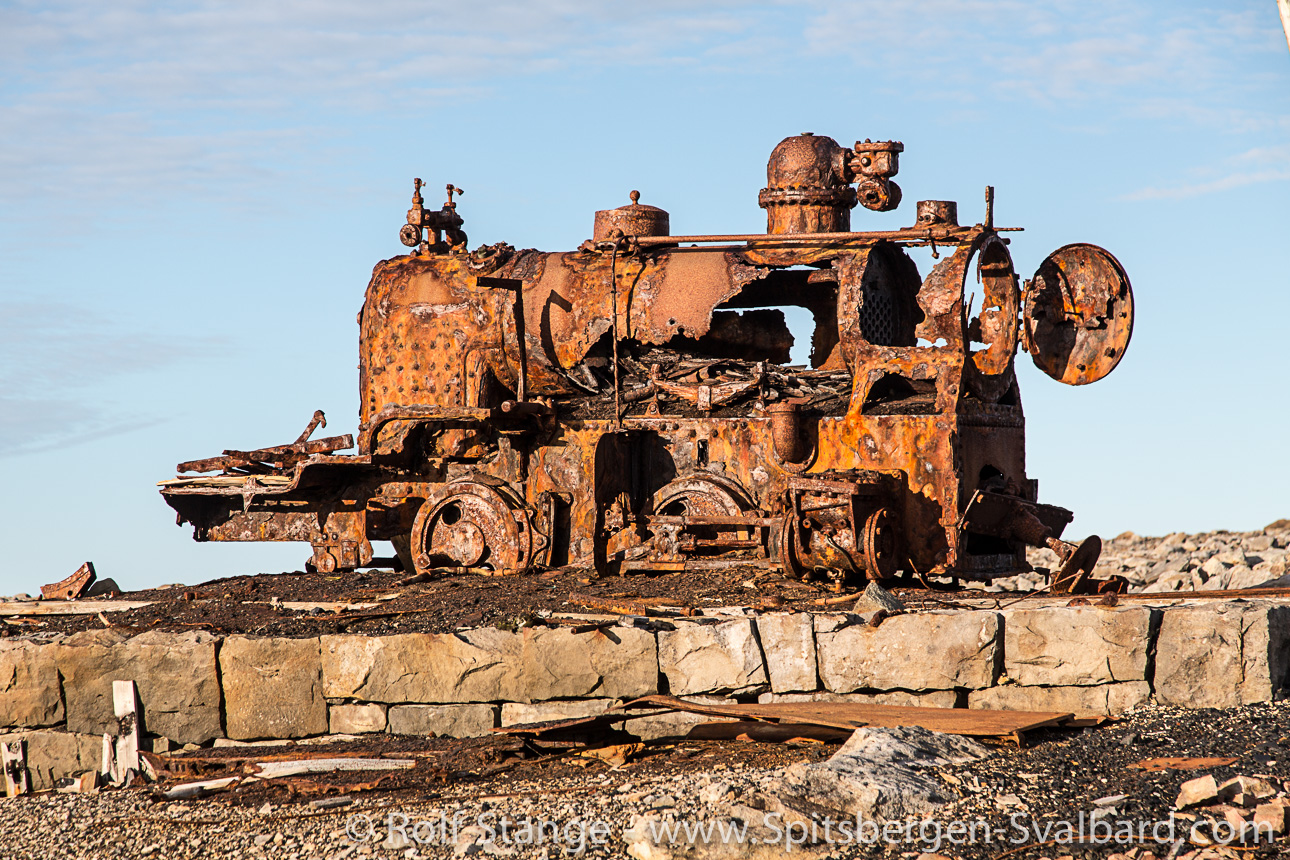
But they did. More than 300 million years ago, Bear Island was not a cold and foggy place as it is today. There was more than enough warmth and sunshine to let large forests grow. The forests turned into coal, and the coal was to be turned into a north Norwegian economic miracle. The only problem: it didn’t work. But they went far enough to build a little railway from the mining settlement Tunheim to the coast. The railway track is now rusting away in the fog, being laughed at by Little auks which are breeding under the stones. Did I mention Bear Island is a place with a lot of stones?
The rest of the coal will remain inside Bear Island until the surf will naturally hammer it out of the rocks. What doesn’t stay where it belongs is the marine relatives of the coal: oil and gas. A while ago, Norway and Russia have agreed quietly and peacefully how the Barents Sea is to be divided between the two of them, and now they are going for it. There won’t be oil riggs on Bear Island, but in the wider neighbourhood. A large oil spill in the Barents Sea might very quickly turn the vertical bird paradise of Bear Island’s coastline into a lifeless rock desert.
After the war, they had the idea to expatriate Nazi collaborators to the barren island in the foggy sea. In the end, the Norwegian Nazis escaped from having to move to Bear Island. On the opposite, tourists who want to get there have to spend quite some effort. There are no flights and no trains to Bear Island. If you really want to get there, then there is no way around a trip on a small ship across the big Barents Sea. Sometimes the sea and the island are friendly, as today, during our visit. Sometimes not. Then it is not a place to be.
We leave before the island changes its mind, setting course for Spitsbergen. More than 120 nautical miles sailing until we reach the south cape.
Bear Island panorama photos
http://www.spitsbergen-svalbard.com/photos-panoramas-videos-and-webcams/spitsbergen-panoramas/bjornoya.html
***
Die Bäreninsel: Grenzstein im Grenzenlosen
Es ist so eine Sache mit kleinen Inseln inmitten von großen Meeren. Je schwieriger es ist, hinzukommen, desto größer ist der Reiz. Desto mehr Mühe scheint sich die Natur ja auch zu geben, etwas Spektakuläres daraus zu machen.
Wenn man mit solchen Gedanken im Kopf die Seekarte vom Nordatlantik hervorkramt, bleibt der Blick schnell bei Jan Mayen und bei der Bäreninsel hängen. Beide sind Ikonen der Einsame-Inseln-in-der-Arktis-Fangemeinde. Weit weg von den nächsten, längeren Küsten, und diese sind schon sehr, sehr einsam. Dazwischen hunderte von Meilen großes, offenes Meer. Was sich für manche in viele, viele Stunden Seekrankheit übersetzt. Nein, davon reden wir nicht, das ist nicht schön.
Jan Mayen wäre auch ein spannendes Thema für einen Blog-Beitrag, aber nun fahren wir gedanklich zur Bäreninsel. Wir machen es genau so wie alle anderen über die Jahrhunderte hinweg. Vielleicht haben es schon die Wikinger so gemacht – eher nicht, aber das wissen wir nicht so genau. Auf jeden Fall haben es Entdecker, Forscher und Walfänger aus Norwegen über Jahrhunderte so gemacht. Sie sind in Tromsø oder Hammerfest auf ein Segelschiff gestiegen und haben gehofft, dass der Wind freundlich ist.
Nun, ganz so machen wir es nicht. Wir steigen auch in Tromsø auf ein schönes Segelschiff, aber wir sind moderne Menschen und haben keine Zeit, auf freundlichen Wind zu warten. Wir fahren einfach los. Notfalls hilft uns dabei der Motor.
Nach ein paar Stunden durch Sunde nördlich der alten Eismeerstadt verschwindet die norwegische Küste langsam hinter uns, während über uns der Wind die Segel füllt – geht doch. 250 Seemeilen liegen vor dem Bug, über 30 Stunden, wenn es gut läuft.
Es läuft gut. In der Begleitung von Buckelwalen und Weißschnauzendelfinen, Dreizehenmöwen und Spatelraubmöwen geht die Zeit schneller vorbei als gedacht. Man muss sich losreißen von der Schönheit der Barentssee an einem gutgelaunten Frühsommertag, damit ein wenig Ruhe für die gedankliche Einstimmung an das seltene Reiseziel Bäreninsel bleibt.
Willem Barentsz war der erste, der nachweislich auf dieser Route unterwegs war. Dass er nicht aus Tromsø kam, sondern aus den Niederlanden, ist nur ein Detail. Schwerer wiegt, dass Barentsz im Gegensatz zu uns weder wusste, dass die Bäreninsel auf seinem Weg liegt, noch irgendein Interesse daran hatte, dort hinzufahren. Das Ziel waren nicht die kalten Inseln im hohen Norden, sondern die gelobten Länder im fernen Osten. Er hatte sich einfach verfahren beim Versuch, einen neuen Weg dorthin zu finden. Am 8. Juni 1596 tauchte vor Barentsz Schiff eine unbekannte Insel aus dem Nebel auf. In den Beibooten unterwegs, wurde die Mannschaft in einen langen Kampf mit einem weißen Bären verwickelt, der sich nur mit viel Anstrengung in die ewigen Robbengründe schicken ließ. Seitdem hat die Insel ihren Namen, der sich auf norwegisch Bjørnøya liest.
Auch unsere Annäherung findet im Nebel statt, für den ist die Gegend bekannt. Wenn es hier irgend etwas gibt, dann Nebel. Aus dem tauchen mehr und mehr kreischende Lummen auf, das Land kann also nicht mehr fern sein. Und tatsächlich tauchen bald hohe Klippen aus den tiefen Wolken auf.
Die Südspitze der Bäreninsel gehört zu den großen Orten, die die Natur im Nordatlantik geschaffen hat. Über 400 Meter ragen senkrechte Felswände aus dem Meer auf. Vorgelagerte Brandungspfeiler zeigen, dass die Insel früher viel größer gewesen sein muss; die höchste dieser Felssäulen genau an der Südspitze, sagenhafte 191 Meter hoch. Dagegen wirkt Helgolands Lange Anna wie Modelleisenbahn-Zubehör.
Wir kommen zur richtigen Zeit. Meist toben Wind und Wellen um die Südspitze, heute ist es aber so ruhig, dass wir die grandiose Südküste der Bäreninsel in Beibooten umfahren können. Die Vogelfelsen sollen zu den größten auf der Nordhalbkugel gehören, und wer sie sieht, will es gerne glauben. Die Brutpaare werden in hunderttausenden gezählt. Man muss schon genau hinschauen, um Dickschnabellummen und Trottellummen auseinanderzuhalten. Die beiden Arten sind Vettern, ähneln sich fast wie Zwillinge.
Die Trottellumme wohnt in der Subarktis, also in Norwegen, Schottland und Island. Freunde der Vogelwelt der Nordsee kennen sie von der schon erwähnten Langen Anna. Aber genauso wie der Felsen selbst, ist die Kolonie auf Helgoland nur ein blasser Eindruck von dem ameisenhaufenhaften Treiben in den Klippen der Bäreninsel. Die Dickschnabellumme hingegen ist eine hocharktische Art, man kennt sie aus Grönland und Spitzbergen. Hier brüten sie beide nebeneinander. Die Verschiebung unsichtbarer Klimagrenzen in Luft und Wasser wird darüber bestimmen, wer hier langfristig wen von der Klippe schubsen wird. Früher waren die Verhältnisse recht ausgeglichen. Allerdings ist der Bestand der Trottellumme auf der Bäreninsel 1987 so stark eingebrochen, dass er sich bis heute nicht vollständig erholt hat. Auf ihrem Speiseplan steht vor allem die Lodde, und den haben Heringe und Menschen ihr damals weggefuttert.
Von der Sorglosigkeit des Menschen im Umgang mit dieser grandiosen Natur zeugt das vor sich hin rostende Wrack eines russischen Schiffes. Der Kapitän war besoffen und der Steuermann schlief auf der Brücke, als die Petrozavodsk im Mai 2009 in die Klippen rauschte. Die Mannschaft wurde gerettet, und die Umwelt auch, indem norwegische Mannschaften unter Risiko Diesel abpumpten und giftige Farbeimer vom Schiff trugen, bevor es später in der Brandung zerbrach. Da hilft das schönste Naturschutzgebiet nichts, wenn man sich nicht dran hält. Seit 2002 ist die Bäreninsel Naturreservat. Strengeres kennt das norwegische Gesetz nicht.
Daher dürfen wir nur mit den kleinen Beibooten und nicht mit dem Schiff um die Vogelfelsen an der Südspitze fahren. Das Schiff hätte auch nicht durch das Perlentor gepasst, norwegisch Perleporten. So heißt die Küstenhöhle, die über 100 Meter lang das Kap Kolthoff durchbohrt. Von Innen erscheint die Bäreninsel dunkel und feucht. Aber wer kann von sich sagen, die Bäreninsel schon einmal von Innen gesehen zu haben? Siehste.
Groß ist die Insel nicht. Keine 10 Seemeilen sind es in den Nordosten. Ums Miseryfjellet geht es herum, der höchste Berg der Insel, dessen 3 Gipfel die Namen alter Schicksalsgöttinnen tragen. Von diesen ist nichts zu sehen, die Spitzen stecken im Nebel. Dass sie den Entdeckern früher das Leben schwer machen konnten, davon zeugt der Name des Berges.
Im Norden zeigt die Bäreninsel ein völlig anderes Gesicht. Ist das wirklich noch die dieselbe Insel? Muss wohl. Immer noch Küstenklippen, fast überall, aber nur noch 10-15 Meter hoch. Dahinter plattes Land. Karg, karger, Bäreninsel. Und steinig. All die Steine, für die der liebe Gott woanders keinen Platz fand, hat er wohl am 8. Tag hier abgeladen, das war ja auch ein Montag, und die Insel war offensichtlich ohnehin nie wirklich dafür vorgesehen, dass dort Zweibeiner herumstolpern.
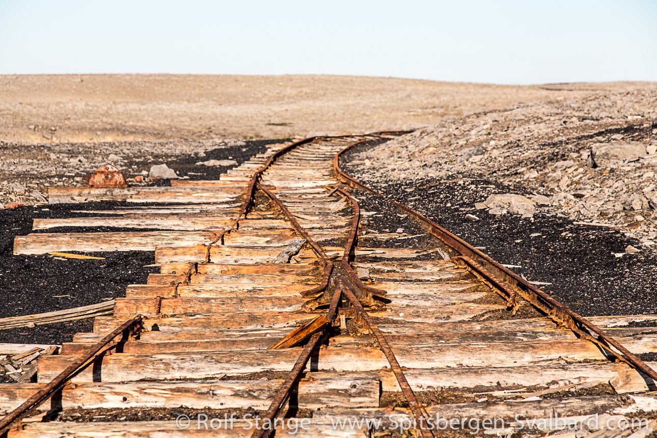
Haben sie aber getan. Denn vor weit über 300 Millionen Jahren schien die Äquatorsonne so lange und so kräftig auf die Bäreninsel, dass in der Wärme Wälder wuchsen. Aus den Wäldern wurde später Kohle, und aus der Kohle könnte doch ein nordnorwegisches Wirtschaftswunder werden, so dachte man. Nur hat es leider nicht funktioniert. Man ging aber tatsächlich so weit, eine kleine Eisenbahn zu bauen, von der Grubensiedlung Tunheim bis zur Verladebucht. Nun rosten die Schienen nutzlos im Nebel, ausgelacht von Krabbentauchern, die unter den großen Felsen brüten.
Der Rest der Kohle wird in den Eingeweiden der Bäreninsel bleiben, bis die Brandung sie eines Tages aus dem Fels schlägt. Was nicht dort bleiben wird, wo es hingehört, ist die marine Verwandtschaft der fossilen Wälder, nämlich Öl und Gas. Norweger und Russen haben den Kuchen schon längst unter sich aufgeteilt – still und friedlich, immerhin – und machen sich nun daran, den Rahm abzuschöpfen. Auf der Bäreninsel wird sich nie ein Bohrgestänge drehen, aber wenn eine Ölpest das Meer verseucht, wird das Vogelparadies ihrer Klippen veröden.
Nach dem Krieg gab es die Idee, Nazi-Kollaborateure aus Norwegen auf die karge Insel in der Abgelegenheit des Nebelmeeres zu verbannen. Den norwegischen Nazis blieb die Bäreninsel erspart. Touristen, die dorthin wollen, müssen sich hingegen ganz schön ins Zeug legen. Kein Flugzeug und keine Eisenbahn führen dorthin. Wer wirklich was sehen will, muss schon viele Meilen lang ein kleines Schiff auf großem Meer auf sich nehmen. Manchmal ist die Insel gut gelaunt, so wie bei unserem Besuch. Manchmal schlecht. Dann wäre man viel lieber woanders.
Bevor sie es sich anders überlegt, setzen wir Kurs auf Spitzbergen. Über 120 Seemeilen bis zum Südkap.
Bäreninsel-Panoramafotos
http://www.spitzbergen.de/fotos-panoramen-videos-und-webcams/spitzbergen-panoramen/bjornoya.html
Das Bäreninsel-Buch
http://www.spitzbergen.de/buecher-dvd-postkarten/die-baereninsel.html
© text and pictures Rolf Stange, http://www.spitsbergen-svalbard.com, 2014

Fab Four,
I’ve heard of Bear Island, but never such close up pictures showing such detailed nature at its grandest. The photos – so clear and sharp – I wanted to hand feed the birds (especially the Puffins, my favorites) and pet the dolphin!! Thank you for this.
GP Cox
LikeLike
Dear GP Cox,
thank you very much for your commentary 🙂
One hardly sees pictures of Bear Island because it’s so remote. Great that Rolf could show us those pics 🙂
We wish you a happy week
the Fab Four of Cley
LikeLike
I don’t know about Bear Island–fascinating and so spectacular! The photos are amazing–they give such a feel for the variety of animals and conditions . . . wow!
LikeLike
yes, indeed, dear Kerry.
Have a happy week
the Fab Four of Cley
LikeLike
Ein wunderbarer Bericht mit großartigen Fotos. Ich habe mir die Panoramen angesehen und kann mich kaum sattsehen. Vielen Dank für diese informative Reise auf eine Insel, von der ich bisher noch nichts gehört hatte.
LikeLike
Liebe Elvira,
da muss man schon Arktisfan sein, um von Bear Island gehört zu haben. Normalerweise kommt man da auch nicht so leicht hin – außer mit Rolf 😉
Vielen Dank und liebe Grüße
the Fab Four of Cley
LikeLike
Many thanks for this detailed tour of an island I expect I will never see. That there are still places like this in our modern world, is something to be cherished. I share the hope that the oil exploration does not change the area, and bring pollution along with it. A great tale, and arresting images. First class as always, KB and Dina. Love and best wishes from Beetley, Pete and Ollie. X
LikeLike
Dear Pete,
thanks a lot 🙂
We were very happy when Rolf promised to write for our Bookfayrie-blog about Bear Island. It’s really at the end of the world – like Jan Mayen – and Rolf is one of the few people who visited this island and knows a lot about it.
We keep our fingers crossed that there will be no oil production.
Lots of love from misty Cley and have an easy week
the Fab Four of Cley
LikeLiked by 1 person
Klasse Fotos. LG. Wolfgang
LikeLike
Ja, Rolf kann wirklich gut fotografieren.
Herzliche Grüße vom nebligen Meer
the Fab Four of Cley
LikeLike
Amazing photos and scenery. Thanks to Rolf, and you for taking us there.
LikeLike
You are very welcome.
All the best
the Fab Four of Cley
LikeLike
Very interesting reading, – inspiring.
He takes good pictures too.
This is places I am going to visit, definitely!
They are on my top three list!
LikeLike
Dear Hans,
good luck for your trip to Bear Island. We hope that you will present great pictures then as well.
Mange takk
Ha en fin dag
the Fab Four of Cley
LikeLike
Lieber Rolf, das sind wirklich atemberaubend schöne Eindrücke von der Insel im Nebelland! Ja, in Norwegen ist die Insel für die meisten Nebeltage weit und breit bekannt, schön, dass es dort auch anders sein kann. 🙂
Anfänglich beim lesen wurde mir fast schlecht, ich kenne die Raue See im Norden recht gut und kann viele stumpfe Stunden Seekrankheit nachempfinden 😉 aber das überspringe ich gerne! Dein Text ist spannend, informativ und unterhaltsam. Hab herzlichen Dank für diesen Beitrag. Sehr gerne würde ich dir nachreisen 🙂 – diese Virtuelle Reise hat großen Spaß gemacht, wie auch diesen Beitrag unten von dir:
Liebe Grüße, Dina
LikeLiked by 1 person
Lieber Rolf,
auch von mir und natürlich auch von Siri und Selma ganz herzlichen Dank für diesen informationsreichen Artikel über einen Ort, an den man eher nicht hinkommt. Tolle Bilder, feiner Text – DANKE!
Herzliche Grüße vom kleinen Dorf am großen Meer
Klausbernd, Siri und Selma
🙂 🙂 🙂
LikeLike
Danke für das sehenswerte Video – das macht wieder Lust auf den hohen Norden 🙂
LikeLike
Toller Filmbeitrag. Die Natur dort ist grandios!
LikeLike
Welch eine fantastische Geschichte…und die Bilder…..traumhaft.
Liebe InselFernwehgrüße von
Gabi
LikeLiked by 1 person
Ganz liebe Fernwehgrüße zurück und vielen Dank fürs Kommentieren.
Hab ‘ne feine Woche
the Fab Four of Cley
LikeLike
Hach, ihr Lieben Buchfeen, Reiselust und Fernweh kommen auf bei diesem großartigen Reisebricht. Vor langer Zeit sah ich “Bear Island” ( Die Bäreninsel in der Hölle der Arktis”) von Alistair MacLean. Dort bekommt man keine Eindrücke von der Insel da der Film in Canada und Alaska gedreht wurde. Jetzt erkenne ich den großen Unterschied zu Realität. Klasse Fotos!
Jürgen
LikeLike
Lieber Jürgen,
zu dem Unterschied zwischen der norwegischen Arktis wie der Bären Insel und der kanadischen Arktis und Alaska kann sicherlich Rolf antworten. Wir “kennen” nur Grönland und die norwegische Arktis, würden aber gerne mal Ellesmere Island besuchen und natürlich auch die Bäreninsel, wo wir auch noch nie waren.
Herzliche Grüße vom kleinen Dorf am großen Meer
the Fab Four of Cley
LikeLike
Die Bäreninsel sieht wunderschön aus, fast mystisch!
Für uns wäre das nichts, aber diese Reise im Lehnstuhl war angenehm warm und fein ruhig! 🙂
LikeLike
Guten Tag, liebe Ursel,
so als Lehnstuhlexplorer zu reisen, das hat doch etwas 😉
Liebe Grüße an Dich und Herbert
von den
Fab Four of Cley
LikeLike
Enjoyed this post very much! Best to you!
LikeLike
THANK YOU 🙂
LikeLike
Ein wunderbarer Bericht von einer wundervollen Insel. Vielen Dank!
LikeLike
You are very welcome – gern geschehen 🙂
Alle Gute
the Fab Four of Cley
LikeLike
My dear friends,
I really like Rolf’s presentation of Bear Island. I read about the oil of Bear Island here in our Swedish paper, but the press was quite sure that Statoil will not produce oil there. I hope so!
Greetings to my dear friends in Cley and to Rolf somewhere
Annalena 🙂
LikeLike
Dear Annalena,
warm greetings back to you in lovely Stockholm 🙂
We are impressed that you saw Bear Island, a few people can say this.
Have a great week and thanks
Love xxx
the Fab Four of Cley
LikeLike
Great post with amazing photos from a part of the world I have never seen – or probably will for that matter, I prefer it warm and cosy. 😉 Now I’m seriously interested in Martin Mosebach’s book, “The Pince of the mist”, but I can’t find it. It this translated or did you just translate the title for us?
LikeLike
Dear Sarah,
“The Prince of the Mist” (original “Der Nebelfürst”) is NOT my translation it’s the title of the English edition of this book. By the way Mosebach is a contemporary German author who is seen as great talent, especially the critiques like him. We found him overrated and “The Prince of the Mist” a bit boring.
All the best and thanks for commenting
the Fab Four of Cley
LikeLike
Thank you, Klausbernd, your opinion is highly appreciated!
LikeLike
🙂
LikeLike
Dear Fab Four of Cley,
I am maybe one of the few readers of this excellent blog who had seen Bear Island. I didn’t set my foot on it but I came very, very near at least. Well, from Spitsbergen (Svalbard) to Bear Island (Svalbard) is not that far – the same group of islands. Unfortunately it has been so foggy when I visited this remote island that saw a kind of mystical shore but not much more. So I am very, very grateful about Rolf pictures.
Thanks to the Fab Four and to Rolf
All the best and warm greetings
Per Magnus
LikeLike
Nice to read from you, Per Magnus! we hope you are all doing well in Weimar. I find the history of Bjørnøya very interesting, I envy the 8 persons staying at the weather station, I’d love to spend 6 months there or on Jan Mayen, (but most of all Spitsbergen). 🙂 Lucky you to have spent so much time there.
Today Bjørnøya ist part of Svalbard, I think Norway acted well when the decision about the islands future taken.
Give our love to the rest of the family – we have great memories of Weimar,
Dina
LikeLike
Dear Per Magnus,
thanks a lot from us in Cley as well.
We envy you 😉
Liebe Grüße xxx nach Weimar
Klausbernd :-), Siri 🙂 and Selma 🙂
What do think of visiting us in January? Think about it. We will ask Annalena as well.
LikeLike
My dear Dina xx,
I envy these meteorologists as well.
Do you remember our friend Vidar (who wrote that beautiful book about Jan Mayen), who was working at the weather station of Jan Mayen? When he had to go back to mainland Norway he tried everything to work in the Arctic again – and he succeeded. The problem is, if you stay for a year or longer in such a remote place in the Arctic it’s very likely you become addicted. You will not enjoy a “normal” life any more.
Health insurance in Denmark acknowledges this Artic-addiction as a treatable illness.
Actually nobody was interested in the Bear Island as well as in Jan Mayen. The Spitsbergen Treatise of 1920 gave Bear Island to Norway.
Love and greetings from us in Cley xxx
Klausbernd 🙂 Siri 🙂 Selma 🙂
LikeLike
Dear Klausbernd,
of course I remember Vidar Teigen! 🙂 I*m still in touch with him and guess where he spent the last 6 months…
http://bjornoya.org/?page_id=16
His 6 months of Bjørnøya has ended, it broke his heart to leave. Sad to say.
Big *hug* to the three of you! xo# xo# xo#
LikeLike
Not really a surprise, isn’t it?
LikeLike
A fascinating Post, a fascinating place. I love the rusting engine. The earth always take back! 🙂
LikeLike
Dear Chillbrook,
Bear Island is one of the few places which are not touristy, but unfortunately that seems to change. My sister told me of a film which shows passengers of a cruise liner dining at the shores of Jan Mayen. I couldn’t believe it. And of course I feel unsure if I should show those places on our Bookfayrie-Blog. People like us and Rolf are (unwillingly) the avantgarde of tourism. It’s like the hippies, when they discovered Katmandu it was a fairy tale place. Today it’s a centre of tourism. I hope that this doesn’t happen to Bear Island. It helps that one has to save quite some money getting there. It’s the same principle we follow in our village here: We make it not easy to reach the highlights like the Blakeney Point (two blogs back you can admire it) and everything is quite expensive. The tourist that come under these circumstances are compatible with nature (like the birders and the hikers).
You are so right! The earth always takes it back …
Thanks and enjoy the evening
the Fab Four of Cley
LikeLike
Great shots of this wonderful adventure – definitely on my to-visit list.
LikeLike
Good luck!
It’s on our to-visit list as well. Maybe we will meet there 😉
We wish you an easy week
the Fab Four of Cley
LikeLike
Outstanding post, both ion its photos (the best!) and history. Felt like you took us with you to a place that I, for one, am unlikely to ever see in real life. Thanks!
LikeLike
Dear Mary,
we are happy that you like Rolf’s text and pictures 🙂
Very few people see Bear Island in real life and that’s good so, otherwise its magic would go.
Thank you and all the best
the Fab Four of Cley
LikeLike
Marvellous, and a place I would dearly love to visit, especially on a sailing ship. Bear Island, with its rocks, rough seas and guillemots and puffins, reminds me a little of Scotland’s St Kilda, a remote island that I have been lucky enough to visit: https://eastofelveden.wordpress.com/2011/06/29/st-kilda/.
LikeLike
Dear Laurence
thank you for the link 🙂 Next time we go up north St. Kilda will be on our list.
To visit those islands of Svalbard with a sailing ship is right way of travelling there, isn’t it? Very romantic …
With warm greetings from Cley next the Sea
Klausbernd 🙂 Siri 🙂 Selma 🙂
Greetings from Dina as well, she is in Bonn right now.
LikeLike
Wonderful tour. Thank you
LikeLike
You are very welcome 🙂
LikeLiked by 1 person
Stunning shots, every single one of them. What an adventure! Thank you so much for the tour, Klausbernd.
LikeLike
Dear Amy,
I was the organizer only, Rolf did write the text and took the photos. I meet Rolf on an expedition to Jan Mayen, Spitsbergen and NE Greenland. He was our excellent guide.
Thank you and have a happy evening
The Fab Four 👭💃🚶of Cley
LikeLike
Dette er fantastiskt vakkert, går rett til mit hjerte! ❤
Thank you all for this really great tour of Bjørnøya! You make me proud, even fonder of my country.
Ha en fin ny uke!
Stor klem fra
Hjerter
LikeLike
Dear Hjerter,
we are really happy that you like Rolf’s post that much 🌞😊 thank you 💐
With lots of love 💞💖
The Fab Four 👭💃🚶of Cley
LikeLike
I have never heard of Bear Island but it really is an intriguing island.
LikeLike
Dear Maria,
Well, Bear Island is unknown to many and very few did visit it. Therefore we are so happy that Rolf wrote a post with pictures for us. You know, we like more or less unknown places. But unfortunately we haven’t been to Bear Island yet.
All the best to you and thanks for commenting
The Fab Four 👭💃🚶of Cley
LikeLike
Very interesting! I had never heard of this island! Thanks for your post. 🙂
LikeLike
You are very welcome 🙂
Your gravatar makes us see you as a birder. Isn’t the Bear Island a great destination for a birdwatcher?
All the best, a happy evening
the Fab Four of Cley
LikeLiked by 1 person
Outstanding post with excellent images! Looks like a true gem, it’s a good thing it’s protected from tourism and now declared a nature reserve.
LikeLike
YES, it really is!
Thanks dear Hans and greetings
from
The Fab Four of Cley
LikeLike
The last photo is top and the post is very interesting.
LikeLike
THANK YOU
Have a nice evening
The Fab Four of Cley
LikeLike
Fabulous photos. I can see where the name “Spitz”bergen came from. Excellent post!
LikeLike
Dear Anneli,
the “Berge” in “Spitzbergen” are very “spitz” 😉 And indeed so the island got its name.
Thank you and we wish you a happy week
the Fab Four of Cley
LikeLiked by 1 person
Wunderschöne Fotos! Die Einsamkeit und Kälte springen mich an und ich bekomme Sehnsucht nach Spitzbergen.
Ich wünsche euch vier eine schöne Vorweihnachtszeit, liebe Grüße von Susanne
LikeLike
Liebe Susanne,
schön, von dir zu lesen. Wir freuen uns, dass dir diese arktische Post gefällt – was mich an unser gemeinsames Projekt erinnert 😉 Spitzbergen ist relativ leicht zu erreichen. Da gibt es Direktflüge seit einem Jahr von Oslo nach Longyearbyen. Aber wenn du in Lomgyearbyen bist, wird es teuer. Du kannst Spitsbergen ja nicht auf eigene Faust erkunden – sorry, aber ich sehe dich nicht als zähe Forschungsreisende a la Alexandra David Neel und schießen kannst du wahrscheinlich auch nicht. Also brauchst du ein Gruppe, guides etc. Anyway, Spitsbergen ist wunderschön und lässt sich noch am bequemsten vom Boot aus erleben.
Ganz liebe Grüße aus dem windigen und regnerischem Cley – und aus Bonn
the Fab Four xx
LikeLiked by 1 person
Very nice post! Like the angle shot of the firs pictures. Those bird pictures are fantastic!
LikeLike
Thank you 🙂
All the best
the Fab four of Cley
LikeLike
Great and interesting shots. It must have been an amazing trip.
If you’ve ever wondered: smoked puffin tastes wonderful!
LikeLike
Dear Reverend,
we knew that guillemots and puffins were eaten by the Inuit. The famous Danish explorer of the Inuit in Greenland, Knud Rasmussen, died of eating rotten birds at his Inuit friends – not properly smoked?
Thanks and have a great day
the Fab Four of Cley
LikeLike
Hehe, rotten birds. What a rotten way to go!
LikeLike
What an irony: Rasmussen was seen as the most beautiful of all explorers and he was known for being meticiously clean and it’s him who dies of eating a rotten bird.
Well, that’s history …
LikeLike
What a great trip Rolf shows through these photos ! Fascinating and wild.
LikeLike
… well, Rolf is a wild guy 😉
thanks for commenting and have an easy week
the Fab Four of Cley
LikeLike
Interessant, dass man sich verfahren musste um diese Insel zu finden. Gezielt die eisigen Welten anzusteuern, wäre mir kaum in den Sinn gekommen, bevor ihr mein Interesse für die Arktis geweckt habt…
Jemanden dabei zu haben, der sich auskennt, ist sicherlich ein Vorteil, danke für die Seele wärmenden Fotos und Reiseberichte.
Ich überlegte mir gestern, wen ich niedlicher fand, den Vogel oder den Delfin (es scheint so einige Delfinfans zu geben….)
Tja, was soll ich sagen, die kleine Hannah kam mit einem weißen Herz aus Papier mit verschlungenen Seilen und 2 Delfinen darauf in den Ballettsaal…..das habe ich für dich gemalt!
Wir zündeten am Ende der Stunde eine Kerze an am Adventskranz , legten das Herz in die Mitte, bildeten einen Kreis (was etwas schwierig ist, denn es gibt auch unter 4jährigen echte Gefühlsverweigerer…)
P: Jetzt sind wir auch verbunden wie der Kranz, wer ist die wichtigste Person in diesem Kreis?
Kind: Niemand!
Kind: Aber wo sind die Kerzen?
P: Du bist die Kerze!
Expedition gelungen, Glück gehabt!
Herzliche Grüße von Pia
LikeLike
Liebe Pia,
viele Inseln sind der Geschichte der Seefahrt entdeckt worden, indem man sich verfuhr. Naja, so wurde im Grunde auch Amerika entdeckt.
In der Hocharktis kann man sich nur mit einem Führer bewegen, allein ist das einzig etwas für Explorer oder Masochisten 😉
Danke fürs Kommentieren und liebe Grüße aus dem regnerischen Cley
the Fab Four
LikeLike
Ein wirklich wundervoller Beitrag, der voller Inspirationen steckt und Fernweh in mir weckt. Ähnlich geht es mir, wenn ich die empfehlenswerten Reiseberichte eines guten Freundes lese (http://vagabondslog.com), der zusammen mit seiner Freundin regelmäßig in einem Kajak die Gewässer um Grönland unsicher macht. Herzlichen Dank für diese Eindrücke.
LikeLike
Vielen Dank für deinen Kommentar 🙂
Da gehen wir doch gleich mal bei deinem Freund gucken. Danke für den Link.
Hab noch einen schönen Tag
the Fab Four of Cley
LikeLike
Einfach toll …
Grüße von der Kräuterfee aus Berlin
LikeLike
Grüße zurück 🙂
von den
Fab Four
LikeLike
Liebe Dina, lieber Klausbernd,
einmal ganz abgesehen von dem wieder einmal, wie immer, ausgesprochen informativen und interessanten Text faszinieren mich ganz besonders die exzellenten Fotos. Aber damit habe ich, zumindest auf meinem Laptop [auf dem Desktop mit großem Monitor habe ich es noch nicht ausprobiert – den nutze ich zu selten], ein Problem: ich sehe die Fotos nie vollständig, sondern muss immer scrollen. Sie füllen die ganze Breite des Blogs aus und sind damit zu hoch. Meine Frage: könntet Ihr die Bilder in einem kleineren Format einstellen? Lässt sich m.W. in WP ja machen. Man kann dann immer noch auf ein Bild klicken und es in voller Größe ansehen, so man das möchte. Natürlich könnte ich auch auf jedes einzelne Bild klicken, damit es verkleinert und an meinen Bildschirm angepasst erscheint, aber das würde den Lesefluss immer wieder unterbrechen und damit das Lesevergnügen nachhaltig beeinträchtigen. Überlegt doch mal bitte.
Mich würde natürlich auch sehr interessieren, ob das nur mir oder auch anderen Lesern so geht. Vielleicht gibt’s hierzu ja bald Kommentare.
Nochmals aber vielen Dank für Euer hochinteressantes Blog.
Liebe Grüße an die gesamte Meschpoke aus einem etwas trüben Fredericksburg,
Pit
LikeLike
Lieber Pit,
nur ganz kurz, da ich in Eile bin: auf PC und Apple mit normalgroßem Bildschirm und auf iPad kann ich die Bilder ohne zu scrollen sehen, sie sind perfekt an meinem Bildschirm angepasst. Aber sicher kann Dina etwas dazu schreiben. Sie und Selmalein kennen sich bei so etwas aus, nehme ich an.
Ganz liebe Grüße dir und Mary
Klausbernd
LikeLike
Hallo Klausbernd,
auf dem grooen Bildschirm meines Desktop PCs klappt es, glaube ich jedenfalls, auch. Und ein I-Pad hat ein anderes Seitenverhältnis als mein Laptop. Das dürfte auch fuer Deinen Apple gelten. Schau’n wir mal, was Dina dazu sagt.
Liebe Grüße,
Pit
LikeLike
P.S.: Ich sehe gerade, du benutzt ja viel kleinere Bildformate auf deinem Blog.
LikeLike
Hallo Klausbernd,
das Bildformat kann man in WP ja einstellen, und da mein Blog ja ein ganz anderes Layout hat als Eures, passen da eben nur kleinere Bilder rein. Und wie gesagt: man kann sie durch Anklicken ja vergrößern – bis auf die Originalauflösung.
Liebe Grüße, Pit
LikeLike
Wieder einmal herrliche Bilder zu dem aufklärenden Text. Ich bin Arktik-, oder Arctic-Begeisteter mit zwei Meter Bibliothek dazu. Grüße zu euch. Ernestus.
LikeLike
Ha, lieber Ernestus, du bist also auch ein Arktis-Fan wie wir 🙂 Bist du ein Lehnstuhlexplorer oder warst du schon mal im allerhöchsten Norden? Es ist dort noch schöner, als es die Bilder zeigen können.
Danke fürs Kommentieren und herzliche Grüße vom sonnigen, aber stürmischen Meer
the Fab Four of Cley
LikeLike
Extraordinary post and photographs! Jawdroppingly beautiful 🙂 It sounds like a very scary place to be in wild weather but it sounds like you were lucky. 🙂
LikeLike
Dear Jo,
we wouldn’t like to go there in rough weather and during the winter when it’s dark all the time and horribly cold.
All the time we travelled to the Arctic we had beautiful weather there. We always went in August and the beginning of Sept., unfortunately you don’t see northern lights (aurora borealis) then.
Thanks and warm greetings from the rough sea
the Fab Four of Cley
LikeLike
This was an extraordinary journey! The photography was spectacular and the details of the adventure allowed me to be there with you. I came back a second time (as I always do for your posts) Many hugs to the Fab Four of Cley!
LikeLike
Dear Rebecca,
warm greetings to Vancouver from sunny Cley. Dina just phoned from Bonn in the Rhine valley, it was snowing there. Greetings from her as well.
We are happy that you like Rolf’s post about this remote island. We thought that our readers would like an introduction to a place they would hardly ever see. We haven’t been there neither but maybe we might go one day.
Thanks and BIG HUGs xxx
the Fab Four
LikeLiked by 1 person
Wonderful to receive hugs from the Fab Four. As I was reading this post, I confess that I was glad that there would be very few that would travel to this special place. That way, I would know that somewhere there is a place that remains untouched, pristine. Does that make sense? Perhaps I am being rather silly. It was wonderful just to see the photos and listen to the conversation. Thank you again, my dear friends.
LikeLike
Dear Rebecca,
we understand you very well. The wise person nowadays travels virtually for ecological reasons. We need wilderness – maybe it’s magical thinking, but we suppose when all wilderness is gone in the outside then there will be no wilderness in the inside neither.
HUGs
the Fab Four of Cley
LikeLiked by 1 person
How very, very, very well said. 🙂 ❤
LikeLike
P.S.:
Siri just found this quote:
“Eisenhüttenstadt represents more than any other place that I can imagine the complexities of dealing with the past.”
That’s from this article you might be interested in
http://www.nytimes.com/2013/11/04/world/europe/east-german-model-city-rusts-quarter-century-after-berlin-walls-fall.html?pagewanted=1&emc=eta1&_r=1&
Lots of Love
Siri 🙂 xx and Klausbernd 🙂 xx from Cley next the Sea
LikeLike
A fascinating place, beautifully captured both in text and photos.
LikeLike
Dear Louis
Great that you like Rolf’s text and pictures 🙂 😊🌞
We wish you a relaxed evening
The Fab Four 👭💃🚶of Cley
LikeLike
Ja, ich war 1973 in Ostgrönland – Angmassalik – Bergsteigen. Schlitten selbst gezogen u.s.w. Ich habe es nie wieder geschafft dorthin zu kommen, aber ich glaube es vergeht keine Woche wo ich nicht an Grönland denke. Solltest du Zugang zu Facebook haben, da habe ich meine Wohnadresse mit Angmassalik angegeben…hahah. Ich habe damals mit einer 6 x 6 Kamera Dias gemacht und vielleicht kann ich sie nächstes Jahr digitalisieren lassen. Mit diesem Format geht das nicht so einfach. Ich hatte auch schon eine Radtour für 2015 ins nördliche Finnland geplant, aber ich meine, allein mit Rad und Zelt erscheint es mir dort doch zu einsam und ich werde wieder in Richtung Mittelmeer fahren. So schaue ich mir so schöne Seiten wie die deine von zu Hause an und werde ein wenig träumen. Viele Grüße, Ernestus.
LikeLike
Lieber Ernestus,
unsere Hochachtung!
Ja, NE Grönland ist auch das Großartigste, was wir gesehen haben. Wir sahen es allerdings immer vom Eisbrecher aus, von dem aus wir mit dem Zodiak an Land gingen. In Nord-Finnland ist unser Masterchen mal länger gewesen als er Lektor des Goethe-Instituts in Finnland war. Ja, ich war dort den ganzen Winter, der großartig mit Nordlichtern und Festen der Samen war. Ich hatte Befürchtungen wegen der deutschen Vergangenheit, aber das war vergessen, well, ich habe Englisch dort gesprochen mit etwas Schwedisch. Als ich als Kind in Nord-Norwegen war, sprach mit meinem Vater keiner, aber ich war kein Problem und meine Mutter auch nicht.
Dina und ich möchten gerne mit Siri und Selma zu den Lofoten. Mal sehen, ob’s und wann es etwas wird.
Liebe Grüße aus Nord Norfolk
the Fab Four of Cley
LikeLike
Reblogged this on Travel perspective, tales, and advice and commented:
This is a fantastic look about the Svalbard archipelago!
LikeLike
Thank you 🙂
LikeLike
Beautiful pictures and stunning scenery. I’m certain this place was the inspiration for Bear Island (http://awoiaf.westeros.org/index.php/Bear_Island) in Game of Thrones.
LikeLike
Dear Malcolm,
we don’t know but maybe Rolf does. We are very sure as well that the real Bear Island inspired the invention of the Bear Island of the game.
Thanks for the link and mentioning this game 💐
All the best
The Fab Four 👭💃🚶
LikeLike
What a spectacular place, and your pictures definitely show it off. I hope it remains wild and wooly forever.
LikeLike
We do that as well!
Thanks and have an easy day
the Fab Four of Cley
LikeLike
Wow, this post was SOOO crazy good!!! What a blessed life you all lead!!! Thanks for sharing it with us.
LikeLike
It’s Rolf’s business to guide people through the Artic and write about it. On one hand it’s great, on the other hand I wouldn’t like travelling more or less all the year round – and with different people all the time. We, Siri & Selma and Dina and our Master, just take a week or two off for travelling and not that often a longer time. We always have to save for big journeys for quite a while.
We are happy that you like Rolf’s text and pictures like we do 🙂 🙂
Thank you 🙂
With warm greetings
the Fab Four of Cley
LikeLiked by 1 person
Alistair MacLean wrote a novel titled “Bear Island”. I would imagine it took place on or near this island. I have read some of his work, but not this particular story.
Puffins are endearing. A naturalist we met near Canon Beach refers to them as “flying potatoes”. Fitting.
LikeLike
Dear Thorsaurus,
you are right, A. MacLean’s last novel “Bear Island” is set on Bear Island – wow, it sold 8 Mio. copies and was filmed.
“Flying Potatoes” – Great!
Thanks and all the best
the Fab Four of Cley
LikeLike
Oh my, this post was like I was in a dream ~ a dream I’ve dreamt a million times. At times I think I must have been explorer who spent most of his life on the sea because just seeing your photos brought back those feeling as if I could taste the salt in the air and spray of the water… A great way to spend a little time, your photos and writing making it all come alive. Beautiful post… Enjoy a well deserved weekend 🙂
LikeLike
Dear Dalo,
thanks a lot and thanks to Rolf again for text and pics.
We immediately looked for a way to travel to the Artic again. The North is addictive, isn’t it?
We wish you an easy weekend as well 🙂
the Fab Four of Cley
LikeLike
Really a great post, and I am thinking about going up north in February when I have a free week, maybe seeing the northern lights. An easy weekend is just what I have planned 🙂 Cheers…
LikeLike
P.S.
Next year we will post Rolf’s Jan Mayen …
LikeLiked by 1 person
….jeder sollte einmal reisen in das schöne Lummerland?! hey, die Eisenbahn verrottet?!
LikeLike
Guten Tag, liebe Pia,
ja, den Norden sollte jeder mal gesehen haben, das finden wir auch.
Die Eisenbahn rottet als Museumsstück dahin, die Arktis wird sie schon niedermachen.
Liebe Grüße
the Fab Four of Cley
LikeLike
Wow, welch wundervoller Bericht, welch fantastische Gegend. Auch die Fotos haben mich sehr begeistert. Am liebsten würde ich mich sofort auf den Weg dorthin machen. Danke, es war eine tolle Reise.
Liebe Grüße von der Silberdistel 🙂
LikeLike
Schön, dass es dir so gut dort gefiel und Reisen ohne Seekrankheit und Kälte in diese doch eigentlich unwirtliche Gegend ist etwas Feines, isn’t it? 😉
Danke, schönes Wochenende und liebe Grüße von
the Fab Four of Cley
LikeLike
Oh ja, so im Warmen zu sitzen und trotzdem überallhin reisen zu können, das hat schon etwas. Mit der Seekrankheit hätte ich da weniger ein Problem. Ich bilde mir ein, recht seefest zu sein 😉
Liebe Grüße und auch Euch ein schönes Wochenende wünscht die Silberdistel
LikeLike
Wonderful – as always with feeling and special touch. Stunning pictures and life hidden to most of us. My husband went to Svvalbard and had a lovely trip in the surrounding waters as well – but i don’t think he saw this island. Thank you to all of you!
LikeLike
Dear Leya,
the islands of the Svalbard group are quite far from each other. From Spitsbergen (the main island) to the Bear Island is quite a journey. And seeing, well, seeing is a problem there as Jan Mayen, Spitsbergen, and the Bear Island attract fog as cold and warm currents meet there.
But we Bookfayries with our dear Master were lucky enough having a sunny day on Jan Mayen.
Enjoy the weekend
the Fab Four of Cley
LikeLiked by 1 person
a m a z i n g … thanks to Rolf and to you, Fab Four, for this breath-taking tour around the island… !!
LikeLike
Dear Alexandra
you are very welcome! 🙂
Great that you like this post 🙂
All the best
the Fab Four of Cley
LikeLike
A fascinating read and wonderful photos. I loved the rusty engine in such a remote place. RH
LikeLike
Dear RH
we did as well 🙂
We wish you a happy week and thanks for your commentary
the Fab Four of Cley
LikeLike
What a wonderful post, with stunning photographs! Thank you for sharing.
LikeLike
You are very welcome 🙂
All the best
the Fab Four of Cley
LikeLike
Jaw dropping is the right word for these images!!! Must have been a life changing adventure. Thank you for taking us along.
LikeLike
Dear Madhu,
we are happy that you liked this Bear Island post. To visit Bear Island is an adventure only very few people experience.
All the best
the Fab Four of Cley
LikeLike
ein fantastischer Reisebericht und vielen Dank für die grosse Arbeit. Ich bin ganz begeistert. Toll. Liebe Grüsse Ernst
LikeLike
Na, das ist ganz prima, lieber Ernst, dass dir der Bäreninsel-Blog so gut gefiel 🙂
Wir wünschen dir eine wunderschöne, gemütliche Vorweihnachtszeit.
Ganz liebe Grüße in die Schweiz vom stürmischen Meer
the Fab Four of Cley
LikeLike
Dramatic nature and beautiful photos. I hope to go to Svalbard one day, any and every part of it would be fine, but it will definitely not be on a sail boat. It brings you too close to the wet part of nature. But lucky you!
LikeLike
Dear Bente,
we keep our fingers and wings crossed that you soon will sail to Svalbard, not on a sailing boat of course. We never did it on a sailing boat, we always travelled on an icebreaker. There you are quite away from the wet element.
Good luck to you as well
the Fab Four of Cley
LikeLike
The birds did a fine job of “painting” the rocks white.
Beautiful, enticing photos of sailing.
I used to have a sailboat, once upon a time.
Sailing is fun….except on extremely windy days…and then, it is downright scary. 🙂
LikeLike
Dear Mary,
we feel like you, sailing is great in sunshine with a little wind but high seas and strong winds immediately spoil the romanticism of sailing.
All the best and thanks for commenting
the Fab Four of Cley
LikeLike
Das ist sehr schön und sehr eindrücklich. Und die Fotos sind der Wahnsinn.
LikeLike
Danke! 🙂
Liebe Grüße
the Fab Four of Cley
LikeLike
Fascinating and beautiful post. Exciting nature images. Hope to get to that part of the world someday.
LikeLike
Dear Jane,
GOOD LUCK, we our fingers crossed that you will see Bear Island soon.
Thanks and all the best
the Fab Four of Cley
LikeLike
my dada sez that luks like a playse ware wun mite ekspekt to enkownter cthulhu hooever that is!!! ok bye
LikeLiked by 1 person
Thank you
👭💃🚶
LikeLike
Interesting post and great photographs.
LikeLike
Thanks 🙂
Happy New Year
the Fab Four of Cley
LikeLike
Tolle Impressionen !
LG Angela
LikeLike
Liebe Angela,
vielen Dank!
Das fanden wir auch.
Hab ‘ne schöne Woche
the Fab Four of Cley
LikeLike
Another amazing photoblog; there is so much here to like but that shot of the railroad ties rusting in place was compelling. I’ve never seen the tracks of mankind decay quite like that.
LikeLike
Dear Dunelight,
the decay of the tracks of mankind … Well, nature takes over culture, but very, very slowly in the Arctic.
Thanks and all the best
the Four of Cley
LikeLike
Toller Bericht !
LikeLike
Schön, dass er dir gefällt.
Danke und noch einen schönen Tag
the Fab Four of Cley
LikeLike
Thank you for visiting my blog, although I am not a camera person , I am a lover of all things creative, I always try to widen my eye for new blogs,I hope we can say in touch
As always Sheldon
LikeLiked by 1 person
Of course, we will stay in touch!
All the best
the Fab Four of Cley
LikeLike
Lovely photos of some familiar places 🙂
LikeLiked by 1 person
Thank you
The Fab Four of Cley
🙂 🙂 🙂 🙂
LikeLike